![[color:aged]](http://elvishmaps.com/cdn/shop/files/CAN_Map_Aged_Warm_Walnut_Blender_Render_1500x.jpg?v=1765506073)
![[color:white]](http://elvishmaps.com/cdn/shop/files/CAN_Map_Original_Warm_Walnut_Blender_Render_1500x.jpg?v=1765530210)
![[color:aged]](http://elvishmaps.com/cdn/shop/files/Snippet_1_BC_AGED_1500x.jpg?v=1765597774)
![[color:aged]](http://elvishmaps.com/cdn/shop/files/Snippet_2_ON_AGED_e2296094-3258-4ed0-8490-bf63ac3face7_1500x.jpg?v=1765597774)
![[color:aged]](http://elvishmaps.com/cdn/shop/files/Snippet_5_Hudson_Bay_AGED_1500x.jpg?v=1765597774)
![[color:aged]](http://elvishmaps.com/cdn/shop/files/Snippet_3_YT_NT_AGED_1500x.jpg?v=1765597774)
![[color:aged]](http://elvishmaps.com/cdn/shop/files/Snippet_4_QC_AGED_1500x.jpg?v=1765597774)
![[color:aged]](http://elvishmaps.com/cdn/shop/files/Snippet_10_BC_Close_Up_AGED_1500x.jpg?v=1765597774)
![[color:aged]](http://elvishmaps.com/cdn/shop/files/Snippet_6_Baffin_Island_AGED_1500x.jpg?v=1765597774)
![[color:aged]](http://elvishmaps.com/cdn/shop/files/Snippet_7_Top_Islands_AGED_1500x.jpg?v=1765597774)
![[color:aged]](http://elvishmaps.com/cdn/shop/files/Snippet_8_Name_AGED_684f3cbb-4cf8-4836-a4d1-859f8646ac58_1500x.jpg?v=1765597774)
![[color:aged]](http://elvishmaps.com/cdn/shop/files/Snippet_9_Compass_AGED_1500x.jpg?v=1765597774)
![[color:aged]](http://elvishmaps.com/cdn/shop/files/CAN_Map_Aged_Black_Frame_Blender_Render_1500x.jpg?v=1765597774)
![[color:aged]](http://elvishmaps.com/cdn/shop/files/Canada_Map_Room_Mockup_Aged_Colour_b60920eb-31e6-479e-9d7c-fe07d8153c2c_1500x.jpg?v=1765597774)
![[color:white]](http://elvishmaps.com/cdn/shop/files/Snippet_1_BC_ORIGINAL_1500x.jpg?v=1765597774)
![[color:white]](http://elvishmaps.com/cdn/shop/files/Snippet_2_ON_ORIGINAL_983d17d7-76b7-4358-8261-eb9b33da16d3_1500x.jpg?v=1765597774)
![[color:white]](http://elvishmaps.com/cdn/shop/files/Snippet_3_YT_NT_ORIGINAL_1500x.jpg?v=1765597774)
![[color:white]](http://elvishmaps.com/cdn/shop/files/Snippet_4_QC_ORIGINAL_1500x.jpg?v=1765597774)
![[color:white]](http://elvishmaps.com/cdn/shop/files/CAN_Map_Original_Black_Frame_Blender_Render_1500x.jpg?v=1765597774)

![[color:aged]](http://elvishmaps.com/cdn/shop/files/CAN_Map_Aged_Warm_Walnut_Blender_Render_1445x.jpg?v=1765506073)
![[color:white]](http://elvishmaps.com/cdn/shop/files/CAN_Map_Original_Warm_Walnut_Blender_Render_1445x.jpg?v=1765530210)
![[color:aged]](http://elvishmaps.com/cdn/shop/files/Snippet_1_BC_AGED_1445x.jpg?v=1765597774)
![[color:aged]](http://elvishmaps.com/cdn/shop/files/Snippet_2_ON_AGED_e2296094-3258-4ed0-8490-bf63ac3face7_1445x.jpg?v=1765597774)
![[color:aged]](http://elvishmaps.com/cdn/shop/files/Snippet_5_Hudson_Bay_AGED_1445x.jpg?v=1765597774)
![[color:aged]](http://elvishmaps.com/cdn/shop/files/Snippet_3_YT_NT_AGED_1445x.jpg?v=1765597774)
![[color:aged]](http://elvishmaps.com/cdn/shop/files/Snippet_4_QC_AGED_1445x.jpg?v=1765597774)
![[color:aged]](http://elvishmaps.com/cdn/shop/files/Snippet_10_BC_Close_Up_AGED_1445x.jpg?v=1765597774)
![[color:aged]](http://elvishmaps.com/cdn/shop/files/Snippet_6_Baffin_Island_AGED_1445x.jpg?v=1765597774)
![[color:aged]](http://elvishmaps.com/cdn/shop/files/Snippet_7_Top_Islands_AGED_1445x.jpg?v=1765597774)
![[color:aged]](http://elvishmaps.com/cdn/shop/files/Snippet_8_Name_AGED_684f3cbb-4cf8-4836-a4d1-859f8646ac58_1445x.jpg?v=1765597774)
![[color:aged]](http://elvishmaps.com/cdn/shop/files/Snippet_9_Compass_AGED_1445x.jpg?v=1765597774)
![[color:aged]](http://elvishmaps.com/cdn/shop/files/CAN_Map_Aged_Black_Frame_Blender_Render_1445x.jpg?v=1765597774)
![[color:aged]](http://elvishmaps.com/cdn/shop/files/Canada_Map_Room_Mockup_Aged_Colour_b60920eb-31e6-479e-9d7c-fe07d8153c2c_1445x.jpg?v=1765597774)
![[color:white]](http://elvishmaps.com/cdn/shop/files/Snippet_1_BC_ORIGINAL_1445x.jpg?v=1765597774)
![[color:white]](http://elvishmaps.com/cdn/shop/files/Snippet_2_ON_ORIGINAL_983d17d7-76b7-4358-8261-eb9b33da16d3_1445x.jpg?v=1765597774)
![[color:white]](http://elvishmaps.com/cdn/shop/files/Snippet_3_YT_NT_ORIGINAL_1445x.jpg?v=1765597774)
![[color:white]](http://elvishmaps.com/cdn/shop/files/Snippet_4_QC_ORIGINAL_1445x.jpg?v=1765597774)
![[color:white]](http://elvishmaps.com/cdn/shop/files/CAN_Map_Original_Black_Frame_Blender_Render_1445x.jpg?v=1765597774)

Frequently Asked Questions
We secure every order either inside a thick, sturdy mailing tube or firm box to ensure a safe, dry and intact delivery.
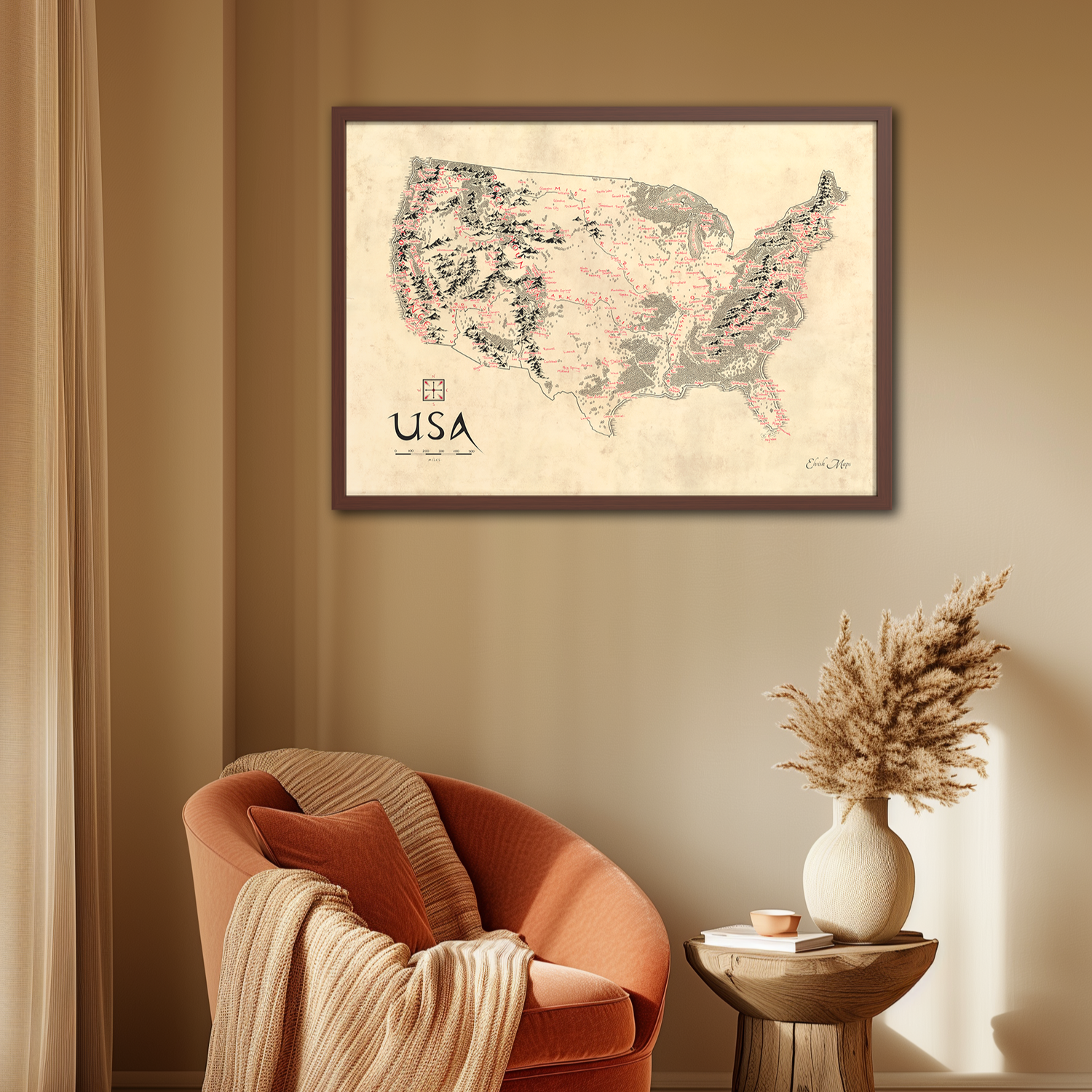
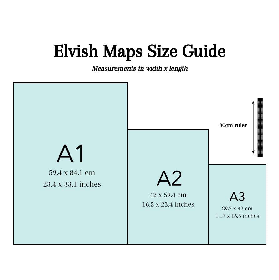
I draw all of my maps at the biggest size I sell, which is A1. Therefore, the clarity is perfect.
All of our maps are printed on thick, high quality 250 gsm museum quality paper.
We have a 30 day returns policy. If you want to return an order, it must be returned in a perfect, sellable condition in order for a complete refund. You must pay for and organise the shipping yourself. To organise returning an order to us, please email elvishmaps@gmail.com.
Yes. We offer three colours for all map sizes (A1, A2, A3), which are black, white & warm walnut - a brownish wood.